New use cases for dual scanning lidar — TI and complex terrain: your webinar questions answered
Our recent New use cases for dual scanning lidar — TI and complex terrain continued our dialogue around the unique value of scanning lidar. Read on for some of the audience questions posted during the webinar, with answers provided by experts from Vaisala and DNV.
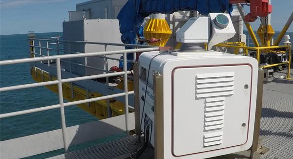
Can you put a scanning lidar offshore on a platform instead of nearshore if needed?
Vaisala: Yes, it can be installed on an offshore platform. This could be useful to place it closer to the area to perform the Wind Resource Assessment campaign.

Do the dual scanning lidar guidelines apply to all manufacturer scanning lidars?
DNV: The dual scanning lidar guidelines apply universally to all scanning lidars, regardless of the manufacturer.

Do you provide dual lidar campaign service and training?
Vaisala provides lidar installation training, practical lidar maintenance training and dual lidar campaign training. Depending on the case, Vaisala will partner with WRA consultants to provide dual lidar service.
Does Vaisala offer any software for processing raw scanning lidar data, in either single or dual scanning mode?
Vaisala: Vaisala already offers software to process and reconstruct single scanning lidar data, and very soon will offer software to process and reconstruct dual lidar data. Stay tuned!
Do you recommend using a single dual scanning lidar to analyze the wind flow, wakes and turbulence conditions in an operational big wind farm in a complex terrain?
Vaisala: I suppose it means using 1 x WindCube Scan. It can be certainly used for those applications. There are several proofs available showing wake measurements in wind farms. For turbulence we would advise to use the dual scanning lidar configuration.
How is the motion correction (Wave & Current) dealt with in a dual scanning device placed on shore?
Vaisala: There's no motion correction when the dual scanning lidar system is installed on shore as the systems will be fixed to the ground.
How to reduce the vertical uncertainty by generating the signal to the desired height which is missed in the configuration?
Vaisala: Simple adjustments of the lidar using the inclinometers can achieve a pointing accuracy of ~0.1°. Further pointing accuracy calibrations should then be done (e.g. using hard target testing, or sea surface levelling) which are taken into account when setting the scans. This can achieve a pointing accuracy of 0.05-0.01°
Nowadays market leaders prefer to have 1-second frequency data sampling. How LiDAR can be used to fulfill the requirements?
Vaisala: Using a WindCube Scan dual lidar setup focused on a single point at a time, we are able to achieve 1s (1hz) frequency of measurement. In some cases we can even achieve 0.5s (2hz) frequency of measurement.
What is the typical CAPEX increase associated with the dual lider approach? Are there near-term opportunities for cost efficiencies as this technology scales in application?
Vaisala: The CAPEX is quite variable depending on the configuration of the system but it would be around 600k€ to 900k€. Several current applications could benefit from the usage of this technology to improve P75/P90 estimations and reduce uncertainties for turbulence intensity. For the near future, the new wind farms for green hydrogen could benefit from dual scanning lidar as these span over tens of kilometers.
Does the dual scanning lidar needs precalibration using a met mast? If so, how many months?
Vaisala: It's not a requirement but for bankability we strongly advise to do it. Usually a 1-2 month campaign is enough to have sufficient data.
DNV: It is both required and recommended to conduct a verification against an IEC-compliant met mast prior to every measurement campaign. Normally, it takes about 6 weeks to complete the verification campaign.
Can we expect a bankable EYA on a complex terrain site - so no need of 1 year of MetMast measurements is needed?
DNV: Whether an Energy Yield Assessment (EYA) can be obtained for a complex terrain site without the need for one year of met mast measurements depends on the specific project. It is not possible to provide a general answer. For accurate guidance, I recommend reaching out to DNV or Vaisala for support regarding any scanning lidar measurement campaigns.
How big area can 2 lidars cover for an onshore project?
Vaisala: It will depend on the environmental conditions of the site. The typical would be approximately 10km2.
How can we use dual scanning lidar, when the site is far from shore (50km), where land deployed DSL will not be useful?
Vaisala: For this case you could perform a DSL lidar measurement up to 10 km from the coast and extrapolate to your site, in addition to a floating lidar located at 50km. Combining the two measurements will reduce your overall uncertainty and may compensate the additional cost of instrumentation [there is a good reference for this]. The TI measurement of the DSL may also be useful.
Since details have been provided by DNV and Vaisala for the bankability of scanning lidar, the question is are there specific financial institutions that approve its use before financial close of a project?
Vaisala: No specific financial institutions can be cited as adopting the guidelines in general. This will be the next step. However, the DNV Vaisala guidelines can already allow financial institutions to better follow and approve dual scanning lidar projects.
Is there any source of uncertainty coming from the installation and parametrization of dual scanning lidars? How can we be sure to compare the same height on the two scanning lidars? 1° of deviation leads to 174m of discrepancy 10km away.
Vaisala: Indeed pointing accuracy can be an important source of uncertainty when measuring at long range if not properly considered in the installation and configuration of the lidars. Simple adjustments of the lidar using the inclinometers can achieve a pointing accuracy of ~0.1°. Further pointing accuracy calibrations should be then be done (e.g. using hard target testing, or sea surface levelling) which are taken into account when setting the scans. This can achieve a pointing accuracy of 0.05-0.01°. The pointing accuracy should still be taken into account in the assessment of uncertainty of the reconstructed paramters - more details are available in our DSL guidelines drafted with DNV.
What is the added value of the second lidar for bankability ? Reduced uncertainties?
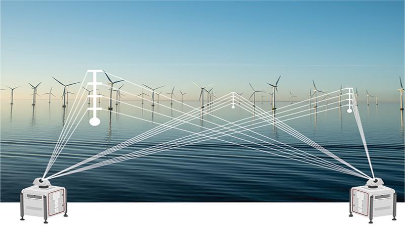
Vaisala: Adding a second lidar allows the wind to be reconstructed at the intersection between the two beams rather than over the area of the arc covered by a single scanning lidar. This reduces the uncertainty of the measurement, increases the possible measurement frequency and reduces the dependence on atmospheric homogeneity.
DNV: The second lidar enables ‘point-like’ measurements with reduced uncertainty compared to using a single lidar, where measurements from a larger volume are used to derive horizontal wind speed and wind direction. Currently, Energy Yield Assessments (EYAs) are only initiated based on data from dual scanning lidar setups at DNV.
Does dual scanning lidar in complex terrain require CFD flow correction like a standard ground based lidar campaign?
Vaisala: No DSL does not experience the same kind of errors in complex terrain as the vertical profiler (which is due to the curvature of the flow across the different inclined beams). The only similar source of error in complex terrain for DSL is the projection of vertical wind speed onto the beams which can be mitigated by using elevation angles close to zero (normally the case) or using a third lidar to capture the vertical component if it is significant.
How much power do you need for one device? How much is data consumption?
Vaisala: Power consumption : 1100W maximum average power (including the use of coolers and heaters), brief peaks up to 1600W. Data consumption: This depends on scan setup. Approximately 1TB per year for each lidar.
How is the procedure for bankable resource assessment? Do you verify both LiDARs at the same mast location? Is there a classification available?
DNV: The DSL guideline document outlines a general procedure, although t’s important to note that specific projects may require variations due to special regulations. For project-specific guidance, consider consulting with DNV or Vaisala.
Regarding verification, it is both required and recommended to conduct a verification prior to every measurement campaign that provides data for energy yield calculations. One option for verifications is the DNV test site in Germany. There, the line-of-sight wind speed of individual lidars and the reconstructed wind speed are verified at an IEC-compliant met mast. A classification for scanning lidar does not exist.
How do you synchronize the LiDARs for time and space (measure at defined distance at the same time)? Can customers set this up?
Vaisala: The WindCube Scan lidars scan strategy is implemented such that both lidars are routinely re-synchronized to ensure sub 1 second synchronization. This is done via a setup of specific synchronization points. The WindCube Scan uses hard targets (buildings, towers, etc) as reference points, to ensure an accurate pointing accuracy. The pointing accuracy is routinely monitored as well. The time synchronization and spatial synchronization is straight forward with the Vaisala dedicated software and process. Customers are trained and provided with the required tools to perform this themselves.
What about different data availabilities on the devices? E.g. fog blocking on line of sight?
Vaisala: The overall availability of the DSL system is the union of the availabilities of the two individual scanning lidars. If the individual availabilities are fully correllated, the overall availability is equal to the individual availabilities. If the availabilities are fully uncorrelated (e.g. due to fog) the overall availability is equal to the product of the two individual availabilities. The reality is somewhere in between, generally closer to the first case.
