Q&A: How the latest version of IRIS Focus enhances situational awareness of weather at airports and beyond
We recently unveiled the latest version of IRIS Focus, an advanced remote sensing software designed to provide superior understanding of storms, weather fronts, wind shear, and turbulence for safe and efficient airplane takeoffs and landings, elevating situational awareness at airports and beyond.
We sat down with Ludovic Thobois, Product Manager for IRIS Focus, to dig deeper into the new and unique features of this powerful remote sensing software.
Q: So Ludovic, tell us - what is IRIS Focus and why is it important for the aviation industry?
A: As our changing climate increases the frequency and severity of extreme weather events, precise weather insights and rapid alerts are more important than ever for meteorologists, forecasters, and decision-makers at the airport. IRIS Focus is a modern and web-based remote sensing software solution that helps professional meteorologists to anticipate weather-related risks, ensuring the safety of passengers, and activities and infrastructure at airports.
Q. Which remote sensing technologies does IRIS Focus support?
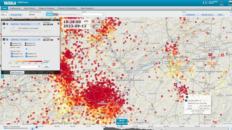
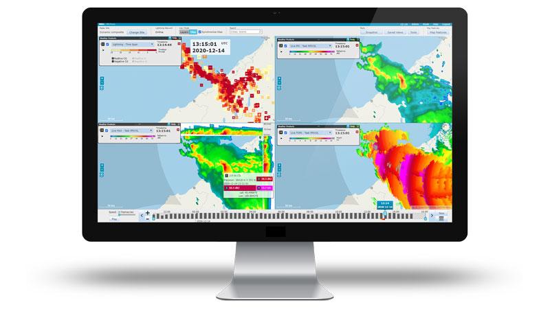
A. IRIS Focus integrates data from various remote sensors, including weather radars such as Vaisala C and X band radars, wind lidars like Vaisala’s WindCube Scan, and lightning detection networks which could, for example, be based on Vaisala’s LS7002, to offer a comprehensive toolkit for weather analysis. The software can also display any kind of data like satellite data or third-party radar network through the Web Map Service (WMS). Overall, IRIS Focus displays all data in an intuitive way and enables easy data sharing through its web-based architecture.
Q: What are some of the unique features that IRIS Focus offers for aviation users?
A: Here are some of the unique features that IRIS Focus offers to support meteorologists and forecasters at the airport to better mitigate weather hazards occurring in the vicinity:
- Windshear detection and alerting along approach and takeoff paths based on weather radar and wind lidar data.
- Turbulence feature that characterizes low-level turbulence using wind lidar data and assesses its severity — critical information for many airports in cities and close to complex topography like mountains.
- Characterization of many types of weather hazards and weather conditions thanks to the set of analysis tools and products available
- Nowcasting feature that indicates upcoming weather hazards and lightning storms up to 2 hours ahead.
- Fully configurable weather events and alerts based on multiple criteria that can be applied for each remote sensor and notified to operational users through email, SMS and Alert API.
Q: How can IRIS Focus support airport meteorologists, forecasters and other users?
A: IRIS Focus empowers meteorologists and forecasters to monitor storms and issue watches and warnings by providing them with high-resolution data and advanced algorithms and tools for hazard detection, tracking, alerting and nowcasting. IRIS Focus also allows them to customize their display settings, color tables, overlays, annotations, and more. The nowcasting feature indicates upcoming weather hazards and lightning storms up to 2 hours ahead.
Whilst IRIS Focus is primarily designed for use by meteorologists and forecasters, it allows them to support their key stakeholders, air traffic controllers and other airport decision-makers to manage operations and optimize flight routes by providing them with real-time data and alerts on weather conditions. IRIS Focus also allows them to create their own areas of interest, sectors, corridors, and flight paths. Furthermore, it offers fully configurable weather events and alerts as mentioned above and this allows to share a situational awareness at the airports with all stakeholders.
Q: How long has Vaisala been developing IRIS software suite and what can you tell us about the future roadmap?
A: We at Vaisala have been developing IRIS software suite for over 30 years and it is the go-to solution for thousands of users worldwide. IRIS Focus was introduced in 2016, and it is the latest addition to the suite that offers a web-based and a modern software for visualizing data from various remote sensors.
We are continuously developing features based on customer feedback - from security patches and bug fixes to new core and optional features. We’re also developing our maintenance, support and services offering to provide a full suite of services for users. So, keep an eye out for upgrade opportunities and stay tuned for future updates. There’s much more to come from IRIS Focus!
Q: Thank you for giving us such a comprehensive overview of IRIS Focus today, Ludovic. Finally, where can people find more information about IRIS Focus?
A: You can visit www.vaisala.com/irisfocus for further details.
We also offer a free trial via: https://www.vaisala.com/lp/try-iris-focus
You can contact your local sales team or Vaisala representative or you can contact us via our online contact form.


