Cutting-edge applications of lidar technology
WindCube® lidar has been tested in complex terrain in China and brings unique advantages to WRA
Nowadays, more and more wind farms are being built. The uncertainty of wind flow measurements in complex terrain is one of the key challenges facing the wind energy industry. Wind farm developers use lidar technology for Wind Resource Assessment (WRA) with proper correction tools to effectively reduce the risk of projects, thereby improving project uncertainty.
In complex terrain, surface, hillsides and other obstacles can cause changes in the speed and direction of the wind field in different regions. WindCube lidar includes patented Flow Complexity Recognition (FCR) software for moderately complex terrain without the need for additional modeling software. For more complex terrain sites, WindCube integrates with CFD modeling tools provided by leading CFD software providers and industry consultants.
Validation campaign in complex terrain in China
A major wind turbine manufacturer and global wind energy solutions provider frequently conducts WRA assessments in China. The organization deeply understands the important role of high-quality WRA for wind farm investment.
In recent years, the wind energy industry has rapidly grown in China. WRA campaigns have faced many unique challenges here, and air flow assessment of complex terrain in mountainous areas is a key topic. The company has more than 20 WindCube lidar units and uses them for measurements in both simple and complex terrains. To evaluate the performance of lidar in complex terrain, they initiated a verification project and ran a four-month measurement campaign at a complex terrain site in the Sichuan Province of China.
Validation for high performance
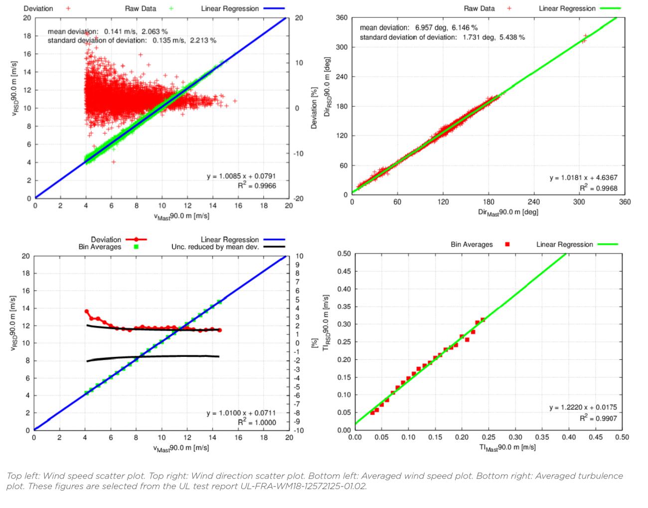
The company set out to validate the performance of the WindCube v2 vertical profiler using FCR. The evaluation process was based on the IEC 61400-12-1 Ed. 2 Annex L [2], and UL served as an independent third-party consultant, reviewing and analyzing the collected data. The results of this campaign are shown in the following figures.
The company positioned the WindCube about 20 meters east of the existing met mast at an elevation of 2838 meters, where they compared lidar measurements to the met mast at 3 different heights (90m, 70m and 50m).

Consistent excellence for WRA
Through four months of the measurement campaign, WindCube showed very good measurement accuracy: Wind speed and direction were consistent with those of the met mast. The results show that the WindCube and its built-in FCR algorithm can provide excellent performance in complex terrain.
WindCube has again proven itself as a trusted standard in wind energy, giving wind industry players confidence of the lidar’s reliable accuracy in simple and complex terrain. The wind energy research team believes WindCube lidar can play its unique advantages in WRA and bring additional value to rapid wind energy development.
Vaisala will continue to analyze the data collected at this site using CFD correction tools. With hybrid wind reconstruction (implemented with WindCube v2.1 units), the bias at this site is further reduced by about 0.5% - 1.0%. Please contact us for more details.
