Cities and the atmospheric boundary layer
European researchers advance boundary layer and air pollution dispersion research with Vaisala ceilometers featuring depolarization technology. Climate change and urbanization are increasing worldwide, yet they are rarely studied together. The ERC urbisphere project was created to do just that.
The client: Universities of Freiburg, Reading, Stuttgart, and FORTH
Vaisala provided: 5 Ceilometer CL61s, 5 Ceilometer CL31s
Capturing boundary layer fluctuations
Funded by the European Research Council (ERC) and conducted by researchers at Universities of Freiburg, Reading, Stuttgart, and FORTH, ERC urbisphere is a synergistic collaboration using a dynamic framework considering weather, exposure and vulnerability of people at a neighborhood-to- city scale. The six-year project includes detailed observations in multiple cities, initially across Europe.
In their campaign in Berlin, Germany, ERC urbisphere researchers Daniel Fenner, Andreas Christen, Sue Grimmond, William Morrison and Matthias Zeeman, amongst others, set up a network to observe how the city affects the air as it travels across the city, including the height fluctuations of the atmospheric boundary layer from rural to urban to rural areas over diurnal and annual cycles.
Many pollutants are released near the surface and the boundary- layer depth controls pollutant concentrations. Measuring the changes in boundary-layer depth (e.g., hour-to-hour) provides awareness of potential changes in pollutant levels, their travel, and their danger to communities.,/p>
The ERC urbisphere campaign consisted of a dense and systematic observation network spread across more than 20 urbisphere and partner sites. The network design considered the predominant wind direction and urban density. The sensors included automatic lidar and ceilometers (ALC) as well as Doppler wind lidars. These instruments provide information about cloud characteristics, boundary-layer height, attenuated aerosol backscatter, 3D wind field and turbulence.
Finding dynamic measurements

The ERC urbisphere researchers complemented the network of ALCs with five Vaisala Ceilometer CL61s and five Vaisala Ceilometer CL31s to provide data about the boundary layer and clouds. Both ceilometers provide cloud height and attenuated backscatter profile data, and the Ceilometer CL61 includes advanced depolarization for precipitation and particulate differentiation.
Researchers distributed the Ceilometer CL61s and CL31s from upwind of the city, to the city center, to downwind of the city, with a dense layout within the city.
The researchers aimed to derive urban modifications of boundary layer characteristics from the measurements including rural vs urban, upwind vs downwind, and intra-urban differences.
New discoveries to inform future research
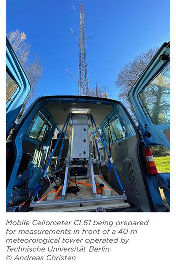
During the campaign, researchers also installed a Ceilometer CL61 in a van where it could take mobile measurements through a roof opening. During these "intensive observation periods," they drove across the city and beyond with occasional pauses at strategic locations.
Using the CL61’s atmospheric profiling and depolarization capabilities, the mobile unit detected a measurable difference in boundary-layer height and aerosol characteristics between the urban and rural areas. On a separate occasion, boundary layer measurements revealed a decrease in boundary-layer depth while the mobile unit was parked in an open field within the city, compared to measurements while driving through the built-up environment.
The ALC network also detected large-scale synoptic events during the campaign. Notably, the CL61s captured plumes of dust originating from the Saharan desert above the boundary layer — complementing the observations of other European wide sensor networks.
Following the Berlin campaign, urbisphere researchers are conducting another campaign in the city of Paris, France with a similar combination of ceilometers and other measurement devices. Multiple city measurements will improve understanding of the variations in aerosols between urban and rural areas and intra- urban variability.
Atmospheric boundary layer and wind dynamics are major factors influencing pollution dispersion. The high density of sensors improves understanding of local variations in weather phenomena and provides knowledge that will help researchers develop and evaluate the next generation of weather models.
As ERC urbisphere progresses and by combining measurements, modelling and social sciences, researchers hope to contribute to the next generation of Integrated Urban Services. These Services are needed to address weather, climate, hydrological and environmental processes in cities, impacting day-to-day operations as well as future planning.
"The high vertical resolution, high signal-to-noise ratio, and depolarization capability of the CL61s are helping us to better understand how the city’s atmosphere and the rural surrounding’s atmosphere vary in terms of mixed- layer height, and their cloud and aerosol characteristics."
Dr. Daniel Fenner, Chair of Environmental Meteorology, University of Freiburg


