Expert article
Lessons from 13 years on the frontline: why reliable weather data matters

Conditions on the ground and in the air are a constant factor in defense operations, shaping what is possible and how safely it can be done. In practice, access to reliable, local weather data is not always guaranteed, particularly when systems fail or connectivity is limited.
Drawing on 13 years in the United States Army, including deployments in Afghanistan, Alex Faulconer now works as a Business Development Manager at Vaisala, focusing on defense. In this article, he shares firsthand lessons from the field and explains why dependable, on-site weather intelligence is critical to mission success.
I spent 13 years in the U.S. Army, including deployments in Afghanistan and missions across multiple regions. One thing that never changed, no matter where I was operating, was the impact of weather.
You can’t change it. But it will always affect you.
I’ve seen sandstorms ground aircraft, extreme conditions damage equipment, and weather shift fast enough to change the outcome of a mission in a matter of hours. In those environments, weather isn’t just background context. It becomes part of the mission itself.
And if you don’t understand it, you’re already at a disadvantage.
When weather becomes the mission
On the frontline, weather directly influences what you can and can’t do.
As a mortarman, accuracy was everything. Even small changes in wind, temperature, or humidity could affect where rounds landed, especially when operating close to your own troops. That’s not theoretical, that’s real risk.
The same applies across operations. Pilots need to understand surface conditions and visibility before landing. UAV operators need to know where cloud cover sits and how wind will affect flight. Ground units need to anticipate how conditions will impact movement, equipment, and safety.
In places like Afghanistan, conditions could change quickly and vary dramatically over short distances. If you weren’t aware of what was happening locally, it could become dangerous very fast.
The gap between data and reality
A lot of modern defense capability relies on digital systems and networked data. In theory, that should make things easier.
In reality, it doesn’t always work that way.
I can’t overstate how many times systems didn’t work the way they were supposed to. Networks fail. Data doesn’t come through. Platforms go down. And when that happens, you’re left making decisions without the information you need.
We used to have a simple mindset: if you don’t trust it, you don’t use it.
That gap between available data and operational reality is exactly why systems like TacMet exist. They’re designed to provide reliable, local weather observations directly at the point of need, without relying on external infrastructure.
In those situations, you fall back on whatever you can rely on. Sometimes that meant going back to manual methods, even in high-pressure scenarios. That’s not where you want to be when accuracy and timing matter.
Why local, reliable data matters
What you really need on the frontline is simple. You need data you can trust, right where you are, when you need it.
Not something that depends on a network. Not something that might arrive too late. Something immediate and reliable.
That’s critical in situations like:
- artillery fire missions where precision is non-negotiable
- helicopter landings in challenging environments
- temporary airfields supporting forward operations
- UAV deployments where conditions at different altitudes matter
In many operations, that local data doesn’t stand alone. It feeds into wider systems, supporting everything from artillery fire control to aviation decision-making. In more advanced setups, surface observations are combined with upper-air data and additional sensors to build a complete picture of conditions from ground level through to altitude.
In all of these cases, decisions are made in real time. The quality of those decisions depends directly on the quality of the data available.
What actually works in the field
After enough time in the field, your requirements become very clear.
Systems need to be:
- simple to use
- quick to deploy
- reliable in any conditions
- independent of external systems
When you’ve been operating for long periods, often under pressure, you don’t have time for complexity. You need something that works every time you turn it on.
From my experience, systems like TacMet make a real difference here. Being able to deploy quickly and rely on the data without needing external connectivity gives you confidence in what you’re working with, and that confidence carries through into your decisions.
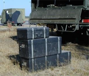
Image: TacMet, packed and ready for deployment. Basic configuration: 2 transit cases, 44 kg. Enhanced configuration: 4 transit cases, 115 kg
Looking ahead
Technology will keep evolving, but the conditions won’t.
Weather will always be there, and it will always have an impact on operations. If anything, the shift toward more distributed operations and increased use of UAVs makes local weather awareness even more important.
The need is simple: understand what’s happening around you, right now.
Because on the frontline, that’s what makes the difference.

Webinar
Vaisala TacMet MAWS201M: Portable weather intelligence for defense air operations
In this webinar, Vaisala experts and a representative from the Canadian Armed Forces will share how portable, rapid-deploy weather systems support modern military air operations. You will see how TacMet MAWS201M delivers accurate, real-time weather observations in environments where permanent infrastructure is unavailable, unreliable, or impractical.
Trust Vaisala to improve your readiness to operate in any weather conditions
Ask us how accurate and reliable weather insights improve your readiness for critical operations.
FAQ: TacMet and frontline weather intelligence
1. What is TacMet and what is it used for?
Vaisala TacMet MAWS201M is a portable, rapid-deploy weather observation system designed for defense operations. It delivers real-time, aviation-grade weather data to support missions such as artillery, UAV operations, and temporary airfields.
2. How quickly can TacMet be deployed in the field?
TacMet is built for speed and simplicity. The basic configuration can be set up in under 15 minutes, allowing teams to start collecting reliable weather data almost immediately, even in remote or austere environments.
3. What kind of weather data does TacMet provide?
The system measures key parameters including wind speed and direction, temperature, humidity, pressure, and precipitation. It can also be expanded with sensors for visibility, cloud height, and freezing rain to support full aviation operations.
4. How does TacMet perform in challenging environments?
TacMet is engineered for harsh conditions, operating in temperatures from −50 to +60 °C with a rugged, IP66-rated design. Its reliability and built-in diagnostics ensure consistent performance when other systems may fail.
5. Can TacMet operate independently of external infrastructure?
Yes. TacMet is designed to work without relying on external networks, with options for battery and solar power and local data delivery. This ensures continuous access to trusted weather data, even when connectivity is limited or unavailable.